The Technological Achievement of Ancient Greece.
Cartography and Geodesy

When the sun rose vertically above the Greek cities, shadows began to shrink. For most people, this was merely an indication of time; for some, however, it was a message from the Earth itself. In the shadow of a simple gnomon fixed into the ground, one of humanity’s boldest ideas was born: that the world can be measured.
In the ancient Greek world, the need to define boundaries, organize cities, and describe roads and seas quietly led to a revolution in thought. Without maps as we know them today, without precision instruments or technological means, the Greeks attempted to transform space into number and land into form. They were not content merely to describe the world; they sought to understand it. Thus, geometry acquired a literal meaning, and geodesy emerged as a fundamental tool of both the state and science. From Anaximander’s earliest attempts at mapping to Eratosthenes’ calculations of the Earth’s size, Greek thought traced a path that combined observation, logic, and boldness. Every measurement was also a challenge to the limits of human knowledge.
The second part of the series on ancient Greek technology takes us into this less illuminated yet decisive field: geodesy and cartography. Here, technology is not expressed through the noise of machines, but through the silence of thought, and precision is not imposed by instruments, but achieved through measure and reason. This is the moment when humanity, looking at its shadow on the ground, began to grasp the magnitude of the world.
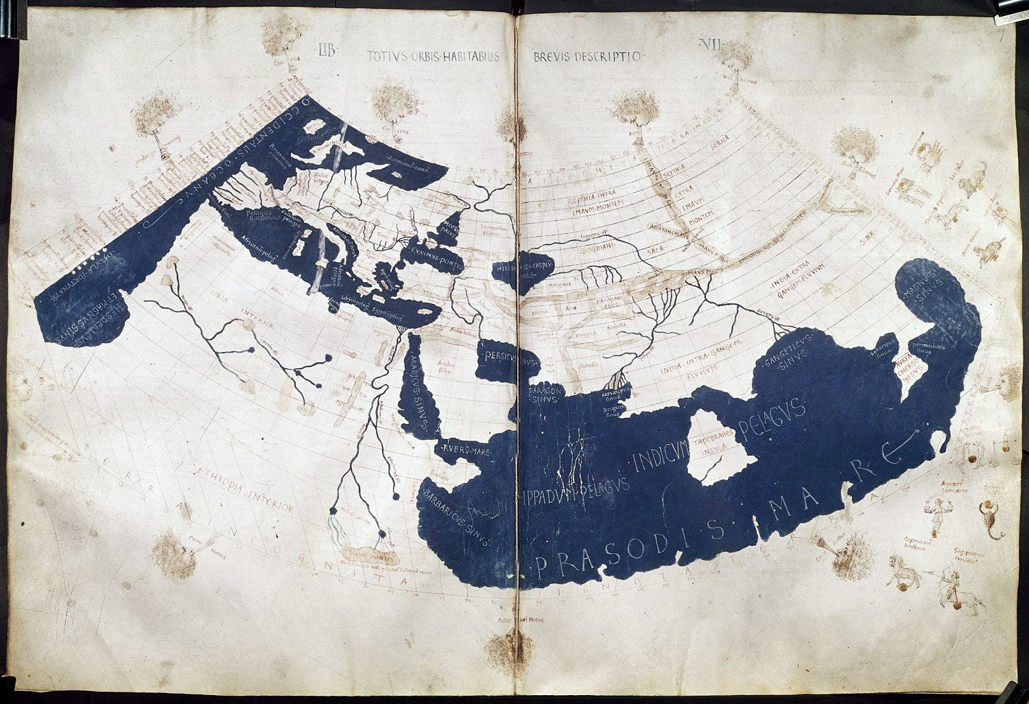
Thales of Miletus calculated distances and heights of inaccessible objects using mathematical proportions. On the magnificent island of Samos in the northeastern Aegean, Eupalinus of Megara (6th century BC) constructed an underground tunnel 1,036 meters long to install a water conduit, remarkably excavated simultaneously from both ends. Hecataeus of Miletus (549–472 BC) and Anaximander of Miletus (610–545 BC) produced a map of the known world (oikoumene), attempting to define the boundaries of existence itself. During the Hellenistic period, surveyors and scientists, aided by odometers and nautical distance-measuring devices, relentlessly and accurately measured distances on land and sea. Pytheas of Massalia (c. 380–310 BC) calculated the coastlines of Britain and Ireland and discovered Thule (Iceland!). At the same time, the map based on a rectangular coordinate system (equidistant grids) was devised, subdivided into stadia, with Rhodes as the central axis. The circumference of our planet was calculated with astonishing accuracy by Eratosthenes of Cyrene (275–194 BC), and the first map with parallels and meridians was constructed, centered on Alexandria. The equidistant cylindrical projection, with equally spaced meridians and parallels adjusted according to the maximum length of the longest day, was conceived by Marinus of Tyre (60–130 BC), and Ptolemy (85–165 AD) succeeded in recording 6,500 place names with geographic coordinates in degrees on the magnificent flat world map of his time.
At some point, the shadow of the gnomon had to become stone and chisel. And this happened on Samos, when geodetic knowledge was transformed into a precise underground work: The Tunnel of Eupalinus.
The Tunnel of Eupalinus
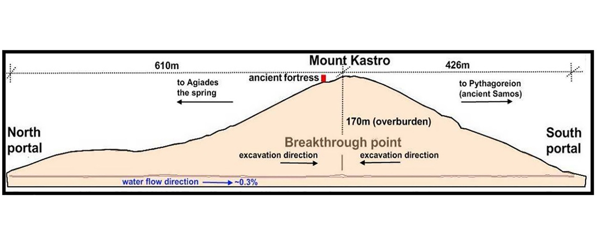
In sixth-century BC Samos, geodesy was tested not on paper but inside the mountain itself. The Tunnel of Eupalinus, approximately 1,036 meters long, was designed as an underground aqueduct to ensure the secure water supply of the city, hidden from enemy eyes and siege threats. The innovation of the project lies not only in its size, but primarily in its construction method: two teams began simultaneously from opposite sides of Mount Kastro, following a pre-calculated geometric alignment, aiming to meet within the rock.
Eupalinus of Megara appears to have used a combination of surface geodetic measurement and underground geometry. On the mountain’s surface, he traced a straight route using a gnomon, ropes, and fixed reference points, while calculating gradients so that the conduit would maintain a steady flow of water. Inside the mountain, excavation followed straight segments, with deliberate angular deviations near the meeting point—an ingenious technical strategy that increased the likelihood of successful convergence, even in the presence of small initial calculation errors.
Of particular engineering importance was the hydraulic solution adopted. The main corridor served as an access and maintenance tunnel, while at a lower level a channel with clay pipes was formed for water transport, allowing controlled gradient and preventing subsidence. The construction accounted for geological discontinuities in the rock, with reinforcements and local changes in cross-section, demonstrating empirical knowledge of rock mechanics. The meeting point of the two tunnels, with a deviation of only a few tens of centimeters, is not merely a technical feat; it is proof of methodology. The Tunnel of Eupalinus shows that ancient Greek engineers did not work through random trial and error, but through planning, error anticipation, and alternative solutions. It is a work in which geometry, geodesy, and practical engineering converge, making it not only a monument of antiquity, but a precursor of modern underground infrastructure projects.
Today, tunnels are excavated using tunnel-boring machines, satellite geodesy, and digital terrain models. Yet the fundamental principles remain the same: alignment, gradient control, error prediction, and management of geological uncertainty. The Tunnel of Eupalinus reminds us that before lasers and sensors came geometric reasoning; before algorithms, proportion; and before modern metro tunnels, an engineer who dared to confront the unknown within a mountain. In this underground work of the 6th century BC, ancient Greek technology stands not merely as a historical precedent, but as a living reference point for the engineering logic that continues to guide major projects today.
The Globe of Crates of Mallus (2nd century BC)
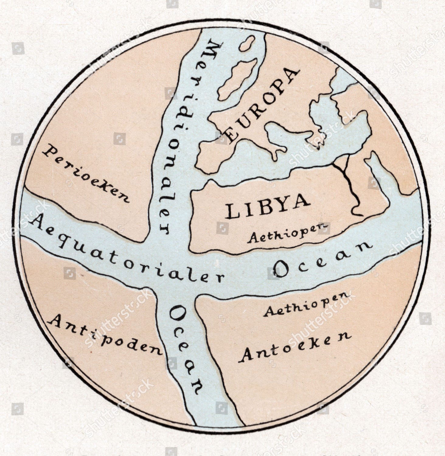
Almost two centuries after Eratosthenes’ calculations, human thought attempted something even more ambitious: not only to measure the Earth, but to contain it within an object. In Pergamon in the 2nd century BC, Crates of Mallus constructed the first known globe, a work combining geography, astronomy, and mechanical representation. This globe did not function as a simple map, but as a three-dimensional model of the world, clearly displaying the axis of rotation, the principal circles of spherical geometry, and the division of the Earth into climatic zones according to the Sun’s position. Influenced by Stoic cosmology, Crates envisioned a planet largely covered by oceans, with continents symmetrically distributed around the equator, emphasizing the unity and balance of the natural world.
Technologically, Crates’ globe represents an early example of scientific modeling. Its construction required knowledge of spherical geometry, proportions, and precise drafting, so that surfaces and distances could be represented consistently on a curved surface. Unlike the flat map, where distortions are inevitable but often invisible, the globe enforced acceptance of the Earth’s curvature and compelled the observer to perceive space as a whole. In this sense, Crates’ globe was not only an educational tool, but also a philosophical statement in favor of a scientific understanding of the world.
The significance of this construction becomes even clearer when compared with modern forms of geographic representation. Today’s globes, digital terrain models, and geographic information systems are based on the same fundamental principle: transforming the Earth into an analog or digital model that can be studied, analyzed, and used for prediction. Where modern science uses satellite data and algorithms, Crates relied on logic, geometry, and observation, demonstrating that the technology of knowledge can precede the technology of means by centuries.
At the same time, Crates’ globe paved the way for the mathematization of geography that would be completed by Ptolemy. The transition from spherical representation to the use of geographic coordinates, parallels, and meridians does not diminish the globe’s importance; on the contrary, it presupposes it. From the handcrafted sphere of Pergamon to real-time-updating digital maps, a continuous line of thought can be traced: the conviction that the world becomes intelligible only after it is transformed into a model. Along this line, the work of Crates of Mallus occupies a position not merely historical, but foundational.
The Dioptra of Hero: When Measurement Becomes an Instrument
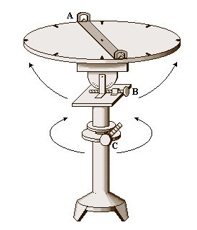
If the Tunnel of Eupalinus demonstrates what geodetic thinking can achieve, and the globe of Crates shows how the world can be represented, the dioptra of Hero provides measurement with its very instrument. In Alexandria of the 1st century AD, Hero described an instrument combining rotating discs, sighting apertures, and angular scales, allowing precise determination of straight lines, angles, and height differences. With the dioptra, one could trace straight alignments, calculate distances, measure heights, and control gradients—exactly the same parameters required by the great hydraulic and urban projects of antiquity. It was not merely a technical aid, but the embodiment of geometry in a mechanical instrument, a precursor to the theodolite and modern geodetic devices. Through Hero’s dioptra, ancient Greek technology shows that it did not remain confined to theory or individual genius, but developed tools that transformed knowledge into repeatable practice.
From the shadow of a gnomon to Hero’s dioptra, from the underground work of Samos to the sphere of Pergamon, ancient Greek technology is woven together by a single thread: measure. Not merely as a unit, but as a mode of thought. Greek engineers and scientists did not aim simply to build; they first sought to understand, calculate, and predict. And therein lies the timeless value of their achievements. Today, in an age of satellites, digital maps, and automated measurements, ancient instruments and works impress us not only for their accuracy, but for the logic that produced them—a logic that approached the world as something that can be measured without being demystified, and understood without being stripped of its wonder. Perhaps that is why ancient Greek technology does not belong exclusively to the past; it continues to remind us that all genuine progress begins with thought, before it passes into tools
Evangelos Axiotis